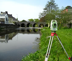
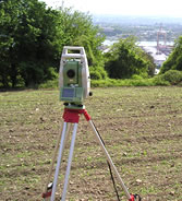
 Topographic maps establish the position and shape of natural and man made features of a given area. Natural features could include water courses, banks, trees, rock outcrops etc. Man made features would include buildings, roads, fences and utility services such as drainage, cables, and street furniture such as public lighting. Contour lines would also be present indicating levels across the site and these can be shown at whatever intervals are required.
Most maps produces by Precise Control are medium to large scale ranging from 1:1000 up to a quite large 1:50 but generally 1:500 and 1:200 are the norm. These maps are usually produced to meet the needs of architects, engineers, developers and government departments.
The information shown on the maps will help determine site layouts for development, volumes for earthworks and can also be used as a basis for land registry. As with most of our work, the information for these maps is determined by gathering data in the form of X, Y & Z co-ordinates using GPS and Total Stations and incorporating field coding techniques. Using CAD packages such as “Liscad” and “Autocad” the finished maps can be provided in 2 dimensional format or in 3 dimensional format if required and are then completed ready for the client.